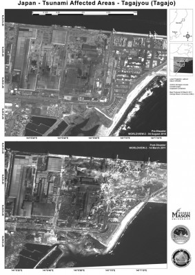
Two mason professors have helped with the relief effort in Japan by analyzing satellite photos like this one.
Members of the George Mason University community are continuing to lend support to the Japan relief effort following the devastating March 11 earthquake and tsunami. Two scientists from Mason’s Department of Geography and GeoInformation Science, Guido Cervone and Germana Manca, were recruited by the U.S. Geological Survey to help analyze satellite images of Japan.
The International Charter Space and Major Disasters organization, which works with “space data acquisition and delivery” for countries afflicted by disasters, activated Japan aid measures at the request of the Japanese government. Cervone said he was then contacted by the USGS to work with these organizations analyzing data.
Cervone, who said his work involves “analysis of remote sensing and model data associated with natural disasters,” worked with images generated by a U.S. satellite called Landsat. He began his work as soon as the images were available, which was the day after the tsunami. For eight straight hours, Cervone and Manca worked with arcGIS software — a geographic information system — to analyze the images assigned by the USGS.
“The goal was to generate high-resolution maps of before and after the tsunami and write up a small assessment of the damages,” Cervone said.
They specifically looked at images in the Iwate and Miyagi prefectures, identifying inundated land, destroyed homes, fallen bridges and collapsed dams. Cervone believes the maps were used to assess devastation, identify areas in need of most immediate help and to assess monetary damage to afflicted areas.
Due to the large amount of images and data, the USGS contracted several companies and two universities, Mason and Clark University in Massachusetts, for interpretation and analysis.
Cervone said that studying and working with information regarding natural disasters is nothing new to the Department of Geography and GeoInformation Science, and that they “constantly follow events worldwide.”
Cervone has worked with Pasquale Franzese, a research associate professor at Mason, creating models representing atmospheric contamination. These models were used by local meteorologist Bob Ryan in discussing Japan’s radioactivity following the disaster. He also worked with Donglian Sun, an assistant professor in the geography and geoinformation science department, analyzing satellite data relating to sea temperature and Hurricane Katrina.


Comments